

Inspiration
Drone Pointilism is an attempt to explore and capture seemingly inaccessible places by means of a drone and a measurement process called photogrammetry. Unmanned Aerial Vehicle-based (UAV) photogrammery is used in commercial applications such as environmental monitoring, earthwork management, and real estate. But could an individual use it to capture 3D models of large vertical structures cheaply and quickly?
Result
Using a Phantom DJI drone I captured pictures of a massive old church dating back to the 1890s - the church of St. Peter and Paul in East Liberty, Pittsburgh - and used them to form a point cloud and 3D mesh of the church's façade.
Tools: Phantom DJI Vision drone, Pix4D software, Meshlab, OpenFrameworks
Deliverable: Stills, point cloud and mesh data, OpenFrameworks code, tutorial
Year: 2015
Link: Code & Tutorial
Role: Solo project
Background & Process
Preserving a historic building in 3D
The grand and beautiful church of St. Peter and Paul's Church was once at the center of a large German Catholic community based in the East End. It was built in 1890, rebuilt in 1909 after a fire, and finally abandoned in 1992 when the parish merged with five other Catholic parishes. I chose such a place for practical but also symbolic reasons. The church's fate is precarious. Will it be demolished? Rebuilt? Or left to rot? If the church were to be demolished, a 3D model of its façade is a way to capture another representation of it for the future.
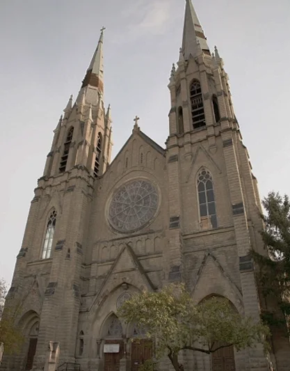
St. Peter and Paul's Church Façade, Pittsburgh, PA
Using a drone for photogrammetry
There are more than a few photogrammetry software solutions in the market that work well (Agisoft, 123D Catch, Memento, Photosynth, pix4D), but each one is tuned for a particular kind of use case and type of image. Agisoft doesn't process images shot with wide angle lenses very well, 123D catch only works for small objects, Memento is still in beta and keeps crashing on me. For this project I used a software called Pix4D geared towards processing drone images that can help you integrate the GPS data captured by the drone quite easily. This improves the image processing tremendously, as the program has a pretty good idea of where the camera was positioned in space to capture each image. For trimming the 3D model I used Mesh Lab and then exported the point cloud to openFrameworks to add some custom color effects.
The footage is shaky because I was piloting the drone, but the 3D model rendered fine


